Note: Our church office is now at Office 5, 9 West End (above Kemsing Motor Company); the map will be updated in due course.
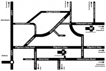
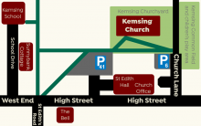
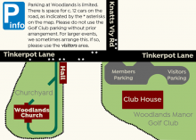
Here are four maps to help you find us.
- One shows you where our two church buildings are in the area around Kemsing and Woodlands.
- The next shows the wider area so that those coming from further afield can find Kemsing and Woodlands from the more major roads.
- Lastly, there are maps of the areas immediately around each church, to help you park and then find the church itself.
Click on either map to view a larger copy.
If you want to print these maps or directions, please click on one of the following links.
Satellite Navigation Details
To find us on a Sat Nav, the following may help you:
Kemsing
- Postcode: TN15 6LU
- Co-ordinates: 51.3065 N, 0.2315 E
Woodlands
- Postcode: TN15 6AA
- Co-ordinates: 51.3236 N, 0.2433 E
Driving Directions to Kemsing
From M25 (Dartford Crossing)
From the Dartford Bridge, stay on the M25 to junction 3. Pick up the M20 for one junction, to leave at junction 2. At the top of the slip-road, turn left along the A20 for three quarters of a mile, then turn left onto Terry's Lodge Road. Follow this under the motorway, across a crossroads, then down a steep hill to reach a T-junction. Turn right onto Pilgrim's Way, then take second left (Cotman's Ash Lane). At another T-junction, turn right. After half a mile, the road enters Kemsing. Pass Church Lane on the right just by the 30mph sign; the village car park is after another 100m on the right.
From M25 (Leatherhead / Gatwick / Clackett Lane)
Leave the M25 at junction 5 (use the right hand lanes to do so) to pick up the A21, which leave immediately following signs for A25 (Sevenoaks). Follow the A25. After 1 mile, turn left then right at two mini roundabouts in Riverhead, then follow A25 for a further mile. At the Bat and Ball traffic lights, turn left onto the A225 for 1.8 miles, passing a large Sainsbury's and going over the motorway.
At a roundabout with a duck pond, turn right to pass Otford Station; just after this, turn right on Pilgrim's Way. After 1 mile, turn right onto Childsbridge Lane (where the road straight is marked with a width restriction). Take the first left (West End). After 0.6 miles, just after passing St Edith Road and The Bell pub on the right, the village car park is on the left.
From the South (A21 Hastings)
Leave the A21 at the exit signed A225 Sevenoaks. At the top of the slip-road, turn right at the roundabout onto the A225. Follow this into Sevenoaks town centre. After passing Sevenoaks School, St Nicholas Church and Knole Park, you reach a fork with HSBC bank inside the fork. Take the right-hand road (High Street). At the far end of the High Street is a signal-controlled crossroads. Go straight across, then take the right-hand fork after 100m into Seal Hollow Road. Follow this for 1.4 miles to reach traffic lights at a T-junction by Trinity School.
Turn right onto the A25 to enter Seal village. Just after entering the village, turn left by a sign depicting some of Seal's history (showing a hot air balloon over the church tower) and by Seal Library. The one-way road goes down a short hill, before turning left into two-way Childsbridge Lane. Follow for 1.6 miles, crossing the railway then the motorway, to turn right into West End. After 0.6 miles, just after passing St Edith Road and The Bell pub on the right, the village car park is on the left.
Driving Directions to Woodlands
From M25 (Dartford Crossing)
From the Dartford Bridge, stay on the M25 to junction 3. Exit at the main junction (not the sliproad onto M20) to join the A20 towards Brands Hatch / West Kingsdown. Cross two further roundabouts, then follow the A20 for a further 3.8 miles. Turn right into School Lane by the Portabello Inn (following a brown sign to Woolands Manor Golf Club). Follow this road for 1.9 miles (which changes name to Tinker Pot Lane). Just after passing the golf club on your left, Woodlands Church is up a short hill on the left.
From M25 (Leatherhead / Gatwick / Clackett Lane)
Leave the M25 at junction 5 (use the right hand lanes to do so) to pick up the A21, which leave immediately following signs for A25 (Sevenoaks). Follow the A25. After 1 mile, turn left then right at two mini roundabouts in Riverhead, then follow A25 for a further mile. At the Bat and Ball traffic lights, turn left onto the A225 for 1.8 miles, passing a large Sainsbury's and going over the motorway.
At a roundabout with a duck pond, turn right to pass Otford Station; just after this, turn right on Pilgrim's Way, then after a quarter of a mile bear left up Row Dow. At the top of the hill, bear right at a triangle; pass Shorehill Lane on the right (signed to Oak Hall), and then bear right into Clarkes Green Road. After 0.8 miles, by which time the road is Tinker Pot Lane, Woodlands Church is on the right, just before Knatts Valley Road on the left.
From the South (A21 Hastings)
Leave the A21 at the exit signed A225 Sevenoaks. At the top of the slip-road, turn right at the roundabout onto the A225. Follow this into Sevenoaks town centre. After passing Sevenoaks School, St Nicholas Church and Knole Park, you reach a fork with HSBC bank inside the fork. Take the right-hand road (High Street). At the far end of the High Street is a signal-controlled crossroads. Go straight across, then take the right-hand fork after 100m into Seal Hollow Road. Follow this for 1.4 miles to reach traffic lights at a T-junction by Trinity School.
Turn right onto the A25 to enter Seal village. Just after entering the village, turn left by a sign depicting some of Seal's history (showing a hot air balloon over the church tower) and by Seal Library. The one-way road goes down a short hill, before turning left into two-way Childsbridge Lane. Follow for 1.6 miles, crossing the railway then the motorway, to turn right into West End.
Follow West End right through Kemsing village; a quarter of a mile after the speed limit derestricts, turn left onto Cotman's Ash Lane. Follow this across Pilgrim's Way, steeply up hill, left at a 90-degree bend, and past the Rising Sun pub, eventually to reach a crossroads. Turn right into Tinker Pot Lane. Woodlands Church is after 0.4 miles, on the right, just before Knatts Valley Road on the left.
By Public Transport
The best railway station to come to is Otford. (Kemsing Station is no closer to Kemsing, has fewer trains per hour, and no service at some off-peak times).
To get to Woodlands, you'd need someone to collect you from the station (or a taxi). With the aid of a good map, you could get there with a pleasant country walk with one steep climb; the distance is about 2.5 miles.
To get to Kemsing from Otford Station, head to the eastbound platform (Platform 2), and leave halfway along the platform where there are some steps and a ramp. Bear right at the top of the steps to head through trees, past Otford Scout Hut. The path gently climbs to reach Tudor Drive. Cross the road to another signed footpath nearly opposite. Follow this for half a mile to reach the western end of Dynes Road. From there, it's another mile to Kemsing Church — see the attached navigation maps.


